Tag: waves

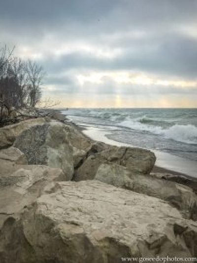
While visiting Canada a few weeks back, we decided to make the trip to Point Pelee National Park. Point Pelee is the southern most point on mainland Canada, not to be confused with the American Southernmost Point, in Florida. It was a chilly, windy day and the waves on Lake Erie were so big it was easy to forget you weren’t looking at the ocean. As the name implies, Point Pelee juts out into Lake Erie like a peninsula with water rushing towards it from both sides. It was unlike anything I had ever seen before (below). Despite the frigid temperatures and unrelenting wind, it was easy to imagine how popular this place is in the summer. The beach would be perfect for relaxing by the water and listening to the surf under the warm sun.

Point jutting out into Lake Erie
At 5 square miles, Point Pelee is smaller than the smallest American Park (Hot Springs National Park is 8.6 square miles), but is still full of things to do. From beachgoing, as I mentioned above to kayaking and hiking, Point Pelee has something to do in every season. The park also offers a unique camping experience called oTENik, which is kind of like a yurt or small cabin that houses groups up to six. I would like to return in the summer and stay in one of these tent-like structures. I don’t believe that traditional camping is offered within the park, although I’m sure you could find a place nearby.
Even though it is a small park and it was so cold, I enjoyed exploring Point Pelee National Park and hope to return in the future. For more information about the park, visit Parks Canada. I am very glad that we took a weekend to discover nearby Canada. It was closer than many places in Michigan and the international hassle was not nearly what I expected it to be. I really do think, weekend and even day trips to Canada will become more of an occurrence for us now.
Thanks for stopping by! To read about some of our previous trips, click here. If you like my photos be sure to “like” my Facebook Page, follow me on Instagram! You can purchase prints on Etsy and Fine Art America. To see inside my camera bag, check out my Gear Page. For information about our new Guided Photography Tours, visit GuidedPhoto.com.

On our first trip to Acadia, we didn’t have time to explore one whole section of the park. The Schoodic Peninsula is the only part of Acadia National Park located on mainland Maine. Schoodic is not as developed as Mount Desert Island, but there are some hiking trails and it also has a drive-able loop road. It is not nearly as crowded at Mount Desert Island. If you are looking to get away from the tourists during your time at Acadia, head over to Schoodic.
The Schoodic Peninsula is about an hour drive from the Hull’s Cove Visitor’s Center and is an easy day trip from Mt. Desert Island. To save on gas, you can catch a ferry from Bar Harbor to Winter Harbor on the Schoodic Peninsula and the Island Explorer bus can take you around the Schoodic side as well. We decided to take the drive on a rainy day and that resulted in an even more deserted experience than I was expecting, but made for some interesting photos!

At the end of the Schoodic Loop Road is Schoodic Point (above). Schoodic Point is a great place to watch the surf pound the rocks, but be careful not to get too close to the edge! Big waves can come up seemingly unexpectedly!
If you have the time on your trip to Acadia, I recommend a jaunt to the quietest part of the park. You can really get a feel for natural Maine at Schoodic and get away from the crowds. The Schoodic Woods campground is the newest campground in Acadia and can be easier to get into than the other campgrounds on Mount Desert Island.
Thanks for stopping by! Read more about this trip, visit the Mainely Acadia Trip Report! To read about some of our previous trips, click here. If you like my photos be sure to “like” my Facebook Page, follow me on Instagram! You can purchase prints on Etsy and Fine Art America. To see inside my camera bag, check out my Gear Page. For information about our new Guided Photography Tours, visit GuidedPhoto.com.
Pin This:


