Travel by Any Means Necessary

Tag: waterfall Page 2 of 7

Yellowstone: Mammoth and Canyon in One Day

Mammoth Hot Springs

Steam coming off Mammoth Hot Springs

This post contains a lot of information about driving around Yellowstone. Here is a link to a map of the park, that will probably be a helpful reference while you read about our first day in Yellowstone.

Our first day in Yellowstone, we came into the park from Cody. I really believe this played a hand in our ability to see so much of the park in just one day. Unlike the west entrance, there was no line coming in from the east side of the park. The first point of interest coming in this way is Yellowstone Lake and the Fishing Bridge area. This is one of the lesser-visited parts of the park and it felt like we were the only people around for miles.

Clouds over Yellowstone Lake

Yellowstone Lake (above) is a sight to behold. Situated at 7700 feet above sea level and taking up 132 square miles, Yellowstone Lake is the largest high elevation lake in North America. Because of the large surface area, sudden gusts of wind can create large waves making open water crossings of the lake very challenging. Because of that and the cold water temperatures, boating on Yellowstone Lake is not incredibly common.
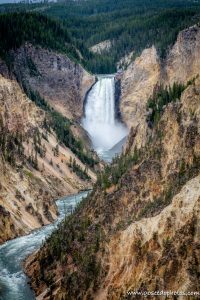
Grand Canyon of the YellowstoneFrom Fishing Bridge, we headed north to Canyon Village and one of my must-sees, Grand Canyon of the Yellowstone. There is a very large parking area in the canyon area and we had no trouble finding a spot to park.  One of the best views of the falls can be found at the Artist Point trailhead (left). I love how even unedited photos of the waterfall look like a watercolor painting. This is one of the most popular areas to hike in the park with plenty of hiking trails for all abilities. For more information about hiking in Yellowstone, visit NPS.gov.

The color of the rock makes The Grand Canyon of the Yellowstone one of the most unique waterfalls I have ever seen. At one time a geyser basin was located at what is now the base of the waterfall. The heat and chemical activity of those geysers created rhyolite, a soft and brittle rock. The rhyolite reacts to oxygen in the air and in effect, the canyon walls are rusting, which gives it that unique yellow color.

From Canyon, we headed toward Mammoth. The drive through that part of the park felt longer than going from Lake to Canyon, but maybe it was just that there isn’t anything to stop and see from Norris to Mammoth. I’m not sure if this is normally the route you would take to get from one area to another, but the road from Tower/Roosevelt to Canyon was closed for construction in 2021.

Mammoth Hot Springs

Mammoth Hot Springs (top and right) was another feature on my Yellowstone Must-See list. I had seen photos of the unique, stair-like geothermal feature and wanted to see it for myself. The water in the springs container calcium carbonate that over time cools and creates these unique rock formations. It was interesting walking around and seeing how the pools have shifted over time, as evidenced by forests of dead trees with white, calcified bases.

Bear and Two Cubs

From Mammoth, we headed to Tower/Roosevelt and this is where we encountered our biggest “jam” of our time in the park. This time, instead of elk, it was a mother bear with two cubs (viewed from a safe distance, of course, and with a ranger standing by with bear spray). It was super cool to see these wild animals through a zoom lens. It was definitely better than seeing them at the zoo!

After our bear encounter, we headed out the Northwest Entrance of the park to Gardiner for dinner. Be sure to stop back next week as I share about our day of exploring geysers and hot springs!

Thanks for stopping by! To read more about this trip, check out the Epic National Park Road Trip. To read about some of our previous trips, visit my Trips Page. If you like my photos be sure to “like” my Facebook Page and follow me on Instagram! You can purchase prints on Etsy and Fine Art America. To see inside my camera bag, check out my updated Gear Page.

Pin This:

Mammoth Hot SpringsPinterest Graphic Grand Canyon of the Yellowstone Pinterest Graphic

Ocqueoc Falls

Ocqueoc Falls

Ocqueoc Falls is the largest and only named waterfall in Michigan’s lower peninsula. When you compare it to some of the grander falls (Tahquamenon, Bond, Munising Falls), Ocqueoc doesn’t really stand out, but at less than an hour’s drive from Mackinaw City or Alpena, it is a fun excursion in the lower peninsula.

One way that Ocqueoc Falls stands out from many other Michigan waterfalls is that you can swim in it. This is a popular northern Michigan swimming hole. Even though it was only 50 degrees out when we visited, a teenager was swimming under the falls. I was glad the long exposure blurred her out or my photos may not have been usable.

With the completion of the bicentennial pathway in 2012, Ocqueoc falls is now accessible to all visitors and is the first universally accessibly waterfall in the United States with a wide path with no stairs from the parking lot to the falls. There is even a tiered transfer station, allowing a person who uses a wheelchair to get in the water. Near the falls is a picnic area with ADA-compliant picnic tables making this one of the most accessible outdoor spaces in the state and possibly the whole country.

Across the street from the falls, there is a rustic state forest service campground with 13 small campsites, an outhouse, and a hand pump for water. Reservations are not accepted, the sites are available on a first-come, first-serve basis. There may not be a lot of amenities, but I’ve heard there is good fishing in the Ocqueoc River which runs through the campground.

Overall, we didn’t spend a lot of time here, but it was a fun stop and would be a great place to explore if someone in your family uses a wheelchair. The campground looks like a nice, quiet place to spend a weekend.

Thanks for stopping by! Be sure to come back next week when I begin the recap of my western National Park adventure! To read about some of our previous trips, visit my Trips Page. If you like my photos be sure to “like” my Facebook Page and follow me on Instagram! You can purchase prints on Etsy and Fine Art America. To see inside my camera bag, check out my updated Gear Page.

Pin This:

Ocqueoc Pinterest Graphic

Wordless Wednesday: Cathedral Room

Cathedral Room at Cascade Caverns

Wordless Wednesday: Eagle Falls

Hiking Eagle Falls

Hiking Eagle Falls

Eagle Falls Kentucky

After booking our campsite for Cumberland Falls, I discovered an Only in Your State article describing Eagle Falls as the best waterfall in Kentucky. So, after our first night in our new camper, we put on our hiking clothes and hit the trail.

The trail to the falls is a mile and a half round trip moderate hike. The trail from the parking area to where you cross Eagle Creek basically has you climb up and down a substantial hill. Once you get to the highest elevation on the trail, there’s a marker for an overlook in .1 miles to the top of the hill. Don’t be tricked by this, there is nothing up there except some old playground equipment. There is no view to be seen from there. Save yourselves the steps when you get a stunning view of Cumberland Falls from the main trail.

Once you cross the river, there is some rock scrambling following paint on boulders. It can be tricky to get your footing, but by the time you get to the falls, it is totally worth it. We got there early and it was after labor day so we were able to sit on the rocks and just watch the falls for a bit with the place completely to ourselves. It was nice way to relax before climbing back to the parking area. Somehow, the trail felt easier on the way back to the car. Maybe Eagle Falls refreshed me.

This is a very popular trail so going early or during the week would allow you to beat the crowds. Going off-season doesn’t hurt either. In the heat of the summer, people flock here to cool off in the pool under the waterfall. It was not warm enough for that when we visited but I can imagine it gets busy in Kentucky heat.

Overall, if you are in the area and have the time and ability for this hike I definitely recommend it. Sitting by the base of a waterfall without another soul around is a very special experience!

Thanks for stopping by! To read about some of our previous trips, click here. If you like my photos be sure to “like” my Facebook Page, follow me on Instagram! You can purchase prints on Etsy and Fine Art America. To see inside my camera bag, check out my Gear Page. For information about our new Guided Photography Tours, visit GuidedPhoto.com.

Pin This:

Wordless Wednesday: Autumn at the Falls

Cumberland Falls

Camping at Cumberland Falls

Cumberland Falls KentuckyWay back in May we ordered a mini camper. Because of supply chain issues and high demand thanks to COVID, it took about twelve weeks for it to be ready. Both our summer road trip and our Labor Day Weekend getaway were planned with the camper in mind. Good thing we’re seasoned tent campers since our camper wasn’t ready until mid-September. I will post more about our toy in a few weeks!

There are no dealers in Michigan that sell this camper so we decided to take a road trip down to a dealer in Tennessee to pick it up. On the way back, we camped at Cumberland Falls State Park near Corbin, Kentucky. The campground at Cumberland Falls is very small. The campground only has 50 sites all together. The sites with electricity are very small and very close together. The maximum length for a rig on the site we were on is only 23 feet so that rules out most campers. The site was the perfect size for our tiny camper for one night on our way home, but I don’t know that it’s a place I would be able to camp at for longer than a weekend. What is great about this campground is how convenient it is to the falls. It is less than a mile from the campground to the parking area. If you are not the camping type, the park is also home to a modern lodge with a restaurant.

The 69 foot tall Cumberland Falls is known as the Niagara of the South. The falls can be viewed from many platforms accessible from the parking. The platforms each give you a different perspective to see the rushing water. Cumberland Falls is the only place in the Western Hemisphere where a moonbow is regularly visible. Similar to a rainbow, a moonbow forms around the time of a full moon over the mist of the rushing water from the falls. Visit the Cumberland Falls website for dates where the moonbow is visible at the park. Overall, I highly recommend a stop at this beautiful natural gem in southern Kentucky!

Thanks for stopping by! To read about some of our previous trips, click here. If you like my photos be sure to “like” my Facebook Page, follow me on Instagram! You can purchase prints on Etsy and Fine Art America. To see inside my camera bag, check out my Gear Page. For information about our new Guided Photography Tours, visit GuidedPhoto.com.

Pin This:


Wordless Wednesday: Waves and Waterfall

Chapel Beach Falls

Hiking Pictured Rocks: Chapel Rock

Chapel Rock

While camping at Tahquamenon Falls, we decided to take a day trip to Pictured Rocks National Lakeshore. The lakeshore has blown up in popularity the last few years after being featured on Good Morning America. We used to refer to Munising as a food desert because if you didn’t bring it with you, you weren’t eating it there. With increased visitation, new restaurants and shops have popped up outside of the park. This was the first time we had been back to this area since our UP Road trip in 2015 and it was really good to see some life in this area!

Chapel FallsThe downside of the increased visitation is that the trails and parking lots were jam-packed with people. We decided to hike to Chapel Falls and there were so many cars on the side of the road to the Chapel Falls parking lot, it took us an hour to drive 3 1/2 miles to the lot. Being a holiday weekend, we were expecting crowds, but we weren’t expecting this level of crowds.

The hike to Chapel Falls (left) is about three miles round trip. The trail is on an old rail bed so it is relatively flat and a pretty easy hike. Somehow, when we got to the falls, Chris convinced me to double the length of our hike and continue on to Chapel Rock and Lake Superior (top). The rest of the trail was just as easy as before and the added mileage meant the crowds dropped off significantly. Overall, I’m glad we did the whole hike, but my legs were jelly by the time we got back to the car.


View this post on Instagram


A post shared by Ashleigh Mowers (@goseedophotography)

If you plan to visit Pictured Rocks, definitely take some time to check out the revitalized downtown Munising. There are now many highly rated places to eat on TripAdvisor. If you plan to do this hike, arrive early, or pack your patience. We arrived after lunch and were able to get a spot in the lot, but as I mentioned above, it took a long time to get all the way there.

Thanks for stopping by! To read about some of our previous trips, click here. If you like my photos be sure to “like” my Facebook Page, follow me on Instagram! You can purchase prints on Etsy and Fine Art America. To see inside my camera bag, check out my Gear Page. For information about our new Guided Photography Tours, visit GuidedPhoto.com.

Pin This:

Chapel Rock Pinterest Graphic


Wordless Wednesday: Falls Through the Trees

Tahquamenon Falls View

Page 2 of 7

Powered by WordPress & Theme by Anders Norén