
Tag: summer Page 3 of 12


Steam coming off Mammoth Hot Springs
This post contains a lot of information about driving around Yellowstone. Here is a link to a map of the park, that will probably be a helpful reference while you read about our first day in Yellowstone.
Our first day in Yellowstone, we came into the park from Cody. I really believe this played a hand in our ability to see so much of the park in just one day. Unlike the west entrance, there was no line coming in from the east side of the park. The first point of interest coming in this way is Yellowstone Lake and the Fishing Bridge area. This is one of the lesser-visited parts of the park and it felt like we were the only people around for miles.

Yellowstone Lake (above) is a sight to behold. Situated at 7700 feet above sea level and taking up 132 square miles, Yellowstone Lake is the largest high elevation lake in North America. Because of the large surface area, sudden gusts of wind can create large waves making open water crossings of the lake very challenging. Because of that and the cold water temperatures, boating on Yellowstone Lake is not incredibly common.
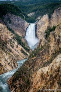 From Fishing Bridge, we headed north to Canyon Village and one of my must-sees, Grand Canyon of the Yellowstone. There is a very large parking area in the canyon area and we had no trouble finding a spot to park. One of the best views of the falls can be found at the Artist Point trailhead (left). I love how even unedited photos of the waterfall look like a watercolor painting. This is one of the most popular areas to hike in the park with plenty of hiking trails for all abilities. For more information about hiking in Yellowstone, visit NPS.gov.
The color of the rock makes The Grand Canyon of the Yellowstone one of the most unique waterfalls I have ever seen. At one time a geyser basin was located at what is now the base of the waterfall. The heat and chemical activity of those geysers created rhyolite, a soft and brittle rock. The rhyolite reacts to oxygen in the air and in effect, the canyon walls are rusting, which gives it that unique yellow color.
From Canyon, we headed toward Mammoth. The drive through that part of the park felt longer than going from Lake to Canyon, but maybe it was just that there isn’t anything to stop and see from Norris to Mammoth. I’m not sure if this is normally the route you would take to get from one area to another, but the road from Tower/Roosevelt to Canyon was closed for construction in 2021.

Mammoth Hot Springs (top and right) was another feature on my Yellowstone Must-See list. I had seen photos of the unique, stair-like geothermal feature and wanted to see it for myself. The water in the springs container calcium carbonate that over time cools and creates these unique rock formations. It was interesting walking around and seeing how the pools have shifted over time, as evidenced by forests of dead trees with white, calcified bases.

From Mammoth, we headed to Tower/Roosevelt and this is where we encountered our biggest “jam” of our time in the park. This time, instead of elk, it was a mother bear with two cubs (viewed from a safe distance, of course, and with a ranger standing by with bear spray). It was super cool to see these wild animals through a zoom lens. It was definitely better than seeing them at the zoo!
After our bear encounter, we headed out the Northwest Entrance of the park to Gardiner for dinner. Be sure to stop back next week as I share about our day of exploring geysers and hot springs!
Thanks for stopping by! To read more about this trip, check out the Epic National Park Road Trip. To read about some of our previous trips, visit my Trips Page. If you like my photos be sure to “like” my Facebook Page and follow me on Instagram! You can purchase prints on Etsy and Fine Art America. To see inside my camera bag, check out my updated Gear Page.
Pin This:


Jewel Cave was discovered in 1900 when two brothers felt cold air blowing out of a hole in a canyon. They opened the hole with dynamite and found a cave lined with calcite crystals, which is where Jewel Cave gets its name. Word of the cave reached Washington and Theodore Roosevelt named Jewel Cave a National Monument in 1908.
Up until 1956, only about 2 miles of the cave had been explored. Famous rock climbers Herb and Jan Conn explored Jewel Cave for twenty years and mapped out over 65 miles of the cave. Herb Conn wrote a scientific paper about airflow in the cave and based on pressure changes, he estimated that 95% of the cave has never been explored. With 209 miles of cave mapped, Jewel Cave is the 3rd largest cave in the world. Experienced cavers are still exploring the cave and finding new rooms and passageways that no other person is known to have explored.
 In 2021, Jewel Cave National Monument is undergoing elevator maintenance to resolve chronic problems with the elevators. The elevators are expected to reopen in the late fall. When planning this trip, I didn’t think we would be able to visit Jewel Cave because of this maintenance, but for now, the park service is offering a modified tour. This tour involves walking down (and then back up) a steep hill and the park service describes it as “moderate to strenuous”.
I’m not sure if people were staying away from Jewel Cave because of the elevator repairs or if this park just isn’t as popular as Wind Cave because it doesn’t have the “National Park” designation. Either way, we arrived around 9:30 AM and there were only a handful of other people on the tour with us. It was a much more relaxed experience and even though we only go to see one room of the cave, I enjoyed this tour a lot more than Wind Cave. If you only have time to tour one cave in the Black Hills, I recommend Jewel Cave.
Thanks for stopping by! To read more about this trip, check out the Epic National Park Road Trip. To read about some of our previous trips, visit my Trips Page. If you like my photos be sure to “like” my Facebook Page and follow me on Instagram! You can purchase prints on Etsy and Fine Art America. To see inside my camera bag, check out my updated Gear Page.
Pin This:


Wind Cave National Park is located in the Black Hills of South Dakota, about 10 miles north of the town of Hot Springs. Wind Cave National Park was established in 1903 by Theodore Roosevelt and was the 7th National Park to be created in the United States, and the first cave to be made a National Park. With 149 miles of explored passageways, Wind Cave is the 7th longest cave in the world.

Wind Cave is a barometric cave, meaning it equalizes the pressure in the cave to the air above which causes the cave to breathe. The cave got its name when two brothers discovered air blowing from a hole in the ground at the natural entrance to the cave. Wind Cave is known for a calcite formation known as boxwork (above). 95% of the boxwork in the world can be found in Wind Cave.
Aboveground,the park is home to the largest remaining mixed-grass prairie in the United States. The grasslands can be explored through 30 miles of hiking trails where bison, elk, pronghorns, prairie dogs, and other animals roam freely.
 The park offers several different cave tours each day but they are very popular and can sell out by mid-morning in the peak season. Knowing this, I arrived shortly after the visitor center opened and had to wait an hour and a half in direct sunlight and unseasonable heat to get tickets. I ended up doing the Natural Entrance Tour which is a longer tour but it doesn’t involve crawling through the cave. They sell 40 tickets per tour so it was pretty crowded in the cave. They try to move so many people through that you are kind of herded through it without really being able to appreciate it. The group I was with was not great and they kept talking over the ranger so all-in-all I did not have a great experience.
I don’t understand why they are not selling tickets in advance. Recreation.gov already exists, the other cave parks are using it for this exact thing. They can save some tickets to be sold same day, but it’s ridiculous that you would have to wait in the hot sun to buy tickets for a tour. I wish there was a way to tour the cave with fewer people and be able to actually appreciate it. It’s possible that some of my bad experience was just due to the other people in my group and if I went back it might be better. If you really like caves or you have a goal to visit all 63 National Parks, obviously you should check out Wind Cave. Otherwise, I enjoyed Jewel Cave (which I will talk about next week) much more.
Thanks for stopping by! To read more about this trip, check out the Epic National Park Road Trip. To read about some of our previous trips, visit my Trips Page. If you like my photos be sure to “like” my Facebook Page and follow me on Instagram! You can purchase prints on Etsy and Fine Art America. To see inside my camera bag, check out my updated Gear Page.
Pin This:


After booking our campsite for Cumberland Falls, I discovered an Only in Your State article describing Eagle Falls as the best waterfall in Kentucky. So, after our first night in our new camper, we put on our hiking clothes and hit the trail.
The trail to the falls is a mile and a half round trip moderate hike. The trail from the parking area to where you cross Eagle Creek basically has you climb up and down a substantial hill. Once you get to the highest elevation on the trail, there’s a marker for an overlook in .1 miles to the top of the hill. Don’t be tricked by this, there is nothing up there except some old playground equipment. There is no view to be seen from there. Save yourselves the steps when you get a stunning view of Cumberland Falls from the main trail.
Once you cross the river, there is some rock scrambling following paint on boulders. It can be tricky to get your footing, but by the time you get to the falls, it is totally worth it. We got there early and it was after labor day so we were able to sit on the rocks and just watch the falls for a bit with the place completely to ourselves. It was nice way to relax before climbing back to the parking area. Somehow, the trail felt easier on the way back to the car. Maybe Eagle Falls refreshed me.
This is a very popular trail so going early or during the week would allow you to beat the crowds. Going off-season doesn’t hurt either. In the heat of the summer, people flock here to cool off in the pool under the waterfall. It was not warm enough for that when we visited but I can imagine it gets busy in Kentucky heat.
Overall, if you are in the area and have the time and ability for this hike I definitely recommend it. Sitting by the base of a waterfall without another soul around is a very special experience!
Thanks for stopping by! To read about some of our previous trips, click here. If you like my photos be sure to “like” my Facebook Page, follow me on Instagram! You can purchase prints on Etsy and Fine Art America. To see inside my camera bag, check out my Gear Page. For information about our new Guided Photography Tours, visit GuidedPhoto.com.
Pin This:
